

Deadly tornado outbreak in South causes 5 confirmed deaths and major damage across the region
LOS ANGELES - Southern states were hit by tornadoes Thursday amid a dangerous severe weather outbreak which also brought large hail, damaging winds and flash flooding across the region.
Calhoun County Emergency Management Agency confirmed five deaths in Calhoun County in Alabama Thursday afternoon, after severe weather ripped through the area.
The latest spate of bad weather comes just one week after a significant tornado outbreak in the South spawned numerous violent twisters in multiple states.
NOAA's Storm Prediction Center (SPC) issued a rare "high risk" severe weather forecast for Thursday from northern parts of Mississippi and Alabama into sections of south-central Tennessee."
Thursday's threat could be as severe, or even worse, than last week's tornadoes and severe thunderstorms across the southeast and mid-Atlantic states, when 47 tornadoes occurred over a two-day period," Bill Bunting, the chief of forecast operations at the NWS’s SPC, told FOX Television stations on Wednesday.
Tornado damage reported in Alabama
Severe storms brought damage to Alabama on Thursday, as parts of the state were threatened by long-track tornadoes, damaging winds and large hail.
"We've seen one very long-track tornado move through central and northeast Alabama and into northwest Georgia, with substantial damage along its path. Too early to assess intensity, and that will have to wait for survey teams from local National Weather Service offices to assess the damage beginning tomorrow," Bunting said Thursday afternoon.
A police officer was struck by lightning while putting out barricades at the intersection of Chisholm Rd and Gresham Rd in Florence, Alabama. Other Florence Police Officers provided immediate first aid and transported him to NAMC where he is being monitored.
According to the Florence Alabama Police Department, he is conscious and responsive at this time.
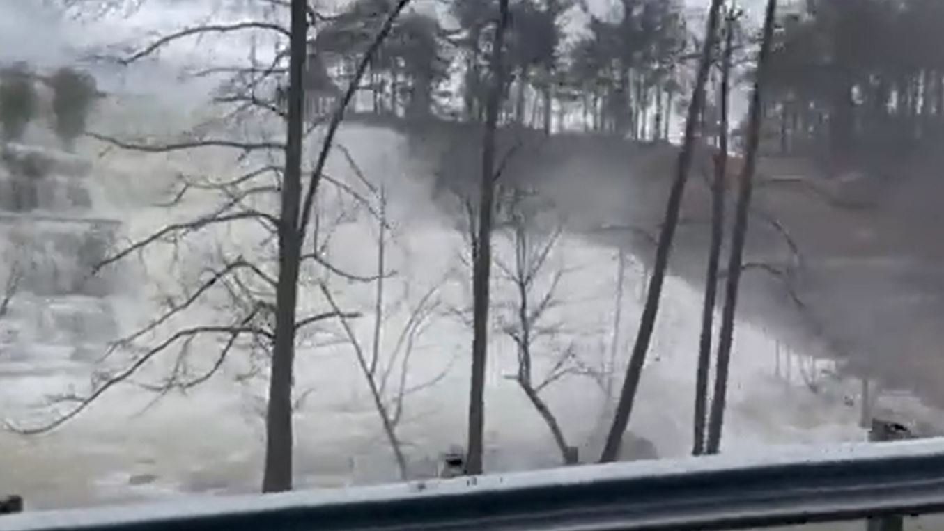
In addition, parts of Cullman County were underwater Thursday morning after severe thunderstorms brought up to 3 inches of rain, the National Weather Service reported.
Video taken by Shaun Burke showed strong waters rushing at Larkwood Falls in Cullman Thursday. "The bridge is about to be underwater," he wrote on Twitter. Photos taken by Burke show the risen Eightmile Creek within inches of the bottom of the bridge crossing over it.
A flash flood warning was in effect for Cullman County. The NWS warned of the possibility of "destructive winds, strong tornadoes, large hail, and flash flooding" across the region.
Meanwhile, video filmed by Twitter user @maritza_reigns showed damage from a possible tornado in her backyard on Thursday afternoon.
A long-lived supercell continued to produce tornadoes in northern Alabama as of 3 p.m. local time, the National Weather Service reported.

The NWS said destructive winds, strong tornadoes, large hail and flash flooding are possible across northern areas of the state. The NWS said a tornado watch was in effect until 8 pm.
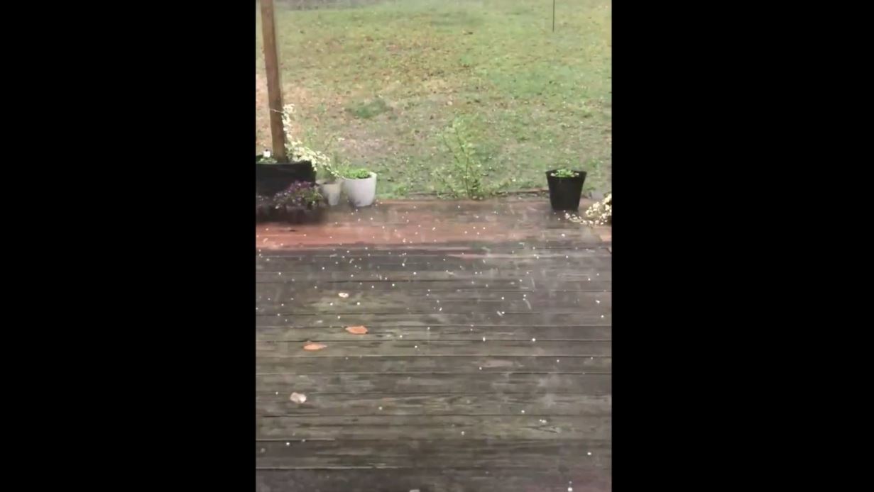
Video shared by Rebecca Latham showed lightning flashes and thunder as hail fell on a backyard in Fort Payne.
"A myriad of weather hazards; both severe and rainfall, are a recipe for a dangerous weather setup in the Mid-South on Thursday," the National Weather Service’s Storm Prediction Center (SPC) wrote in its forecast discussion.
Timing of potential tornado outbreaks
The severe threat is expected to develop and peak Thursday afternoon and may linger into Thursday night across the Tennessee and Ohio Valleys while the Northeast contends with periods of rain overnight Thursday.
"Additional storms will have tornado potential in Alabama through this tonight, and we've also issued a new Tornado Watch for portions of southern Illinois, western Kentucky, and western and middle Tennessee through this evening," Bunting said. "The main emphasis now is to let everyone know that the threat for tornadoes and severe thunderstorms will persist for several more hours, and people should not lower their guard."
Clancie Daley captured video of an ominous funnel cloud in southeast Brookhaven, Mississippi, around 12:45 p.m. on Wednesday. Brookhaven was under a tornado warning until 1:45 p.m., per the NWS.
The threat of severe weather will taper off as the storm system moves east on Friday.
"People in the affected areas need to make sure that they have a severe weather safety plan that includes where to take shelter in the event a severe storm approaches, and have more than one way of receiving severe thunderstorm and tornado warnings," Bunting said.
"A NOAA Weather Radio can be programmed to alert you when warnings are issued for your county or parish, and can wake you up if the storm occurs when you are sleeping," Bunting continued. "It's very important to have thought about safety before the warnings are issued."
A violent start to tornado season
While tornado season typically runs from March through June, it has been off to an active start.
Last week, tornadoes knocked down trees, toppled power lines and damaged homes in several communities. More than 70,000 homes and businesses were without power from Texas to Alabama.
The National Weather Service warned people in the Demopolis area of Alabama to take cover as a storm moved through on March 17, bringing a tornado threat.
RELATED: South braces for another dangerous tornado outbreak that could be ‘even worse’ than last week’s
"It is difficult to predict how an entire season will play out just based on early season activity, but we are entering the time of year when severe thunderstorms and tornadoes most often occur," Bunting wrote.
"Regardless of whether the season is above or below normal, everyone needs to prepare for the possibility of severe storms now, and make sure you have multiple ways of receiving life-saving severe storm warnings. It only takes one storm to make it a bad year if it affects you!"