

Keep the umbrella handy: Rain returns to Central Texas this week

Morning weather forecast for February 9, 2020
Chelsea Andrews has the morning weather forecast for February 9, 2020.
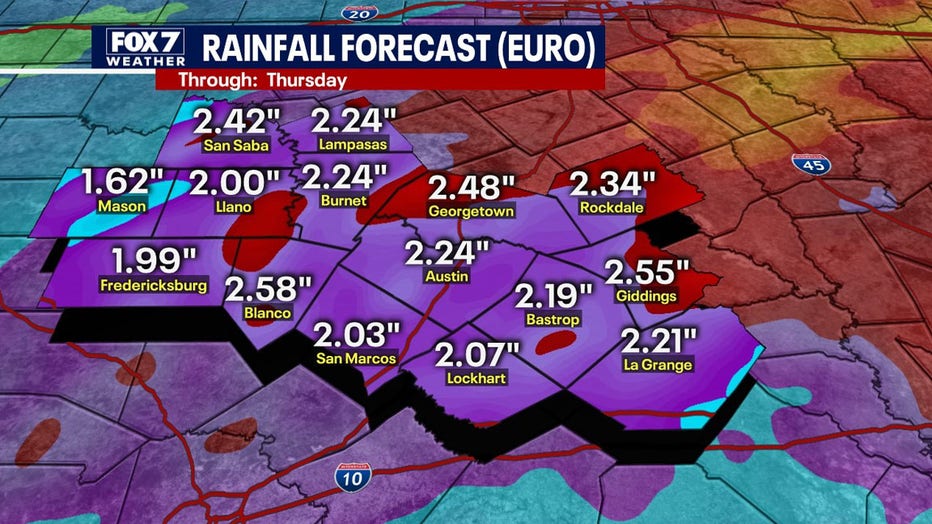
AUSTIN, Texas - Much-needed rain returns to Central Texas this week with some sites expected to see more than 2” through Wednesday.
As Gulf moisture moves into our region this week, a cold front and an upper-level low-pressure system over the Desert Southwest will help to trigger showers and storms.
During the day Sunday, a few scattered showers will move in from the south, likely bringing between a tenth and a quarter of an inch of rain.
Into Monday, a cold front will arrive early in the day. Most across the region will see high temperatures in the low-to-mid 60°s ahead of the front with temps cooling into the 40°s and 50°s through the afternoon.
Behind the front, an upper-level disturbance will move in from the southwest, producing more showers and thunderstorms.
Cool, damp conditions are expected Tuesday but the best chance for showers, some heavy, will be Tuesday night into Wednesday. During this time, an upper-level low-pressure system will eject out of the Southwestern United States into Texas.
As this area of low pressure moves east during the day Wednesday, dry air will filter in, in its wake, clearing out the showers throughout the day.
On average, most around the area can expect to see between 1” and 2” of rain through the middle of the workweeks. Widespread flash flooding is not a major concern at the moment, given the drought conditions throughout Central Texas. However, residents should pay attention to weather conditions and monitor future forecasts for possible changes.
Track your local forecast for the Austin area quickly with the free FOX 7 WAPP. The design gives you radar, hourly, and 7-day weather information just by scrolling.
Our weather alerts will warn you early and help you stay safe during storms.