

Flood watch issued for much of Central Texas

Austin weather: More rain expected on Tuesday
Central Texas could see some more scattered showers on Tuesday. Leslie London has the latest details
TEXAS - A Flood Watch has been issued for several Central Texas counties until 7 a.m. on Tuesday, July 15.
Flood Watch
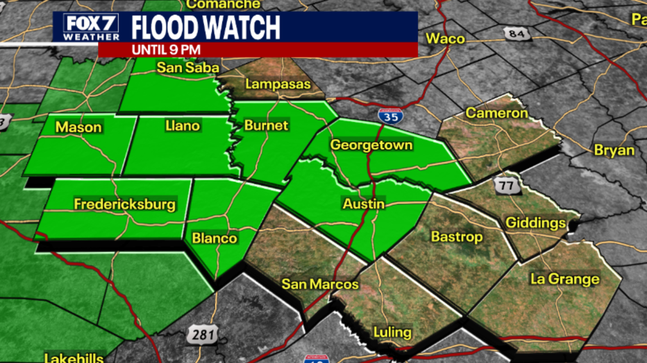
The National Weather Service says the Flood Watch will remain in effect until 9 p.m.
Additional quick rainfall amounts of 1 to 2 inches are possible within heavy downpours with isolated amounts of 3 to 5 inches possible.
Excessive runoff would result in possible flash flooding and rises in already above-normal river levels, according to the NWS.
July 14 updates
7:02 p.m.
A flood watch was extended for San Saba and Mason counties until July 15 at 7 a.m.
5:47 p.m.

Texas floods: Highland Lakes filling up
The San Saba and Llano Rivers were in flood more over the weekend. That water has been flowing downstream, filing Lake Buchanan and Travis
"On average, we picked up 3 to 6 inches of rain in some spots, 6 to 12 inches of rain, putting the San Saba and the Llano Rivers in flood mode for the second time in the last week," FOX 7 meteorologist Zack Shields said.
The San Saba River crested at 31 feet.
"The projection shows it staying at moderate flood stage," he said.
The Llano River crested at 17 feet.
Lake Buchanan is 97 percent full. It's gone up 15 feet since July 1. Two floodgates opened on Monday. The last time that happened was in 2019.
Lake Travis is 79 percent full, up 28 feet from July 1.
"We still have a long way to go to see Lake Travis go up before they're going to have floodgate operations at Mansfield Dam. Now basically these lakes are doing what they're supposed to do, capturing floodwaters," Shields said.
2:56 p.m.
A flood watch has been extended for several Central Texas counties until July 15 at 7 a.m.
The watch is for the following counties: Gillespie, Blanco, Travis, Llano, Burnet, Williamson, and Hays.
2:07 p.m.
An evacuation order for San Saba County was canceled.
1:30 p.m.
A flood warning has been canceled for San Saba, Lampasas, and Mason counties.
12:30 p.m.

Austin weather: Flood watch in effect for tonight
A Flood Watch is in effect for the Texas Hill Country and even Travis and Williamson counties until tonight following more rains over the weekend. Meteorologist Zack Shields has the latest.
FOX 7 Austin meteorologist Zack Shields says the flooding risk is staying with us from I-35 to the Hill Country.
Starting by mid-afternoon, scattered downpours will begin to show up in the Hill Country. Then the storms will start to fill in closer to Austin by late afternoon.
11 a.m.
A Flood Warning is now in effect until late Tuesday morning (July 15) for the area around the Llano River.
The NWS says that at around 4 a.m. Monday (July 14), the stage was at 15 feet; 10 feet is flood stage.
16 feet means moderate lowland flooding will threaten docks and boats in the flood plain downstream in Kingsland. Secondary roads and bridges will be flooded and dangerous to motorists.
The NWS says that the river is expected to fall to 11 feet later Monday morning, then rise and fall over the course of Monday, before falling below flood stage late Monday evening.
9:38 a.m.
The Flash Flood Warning for Burnet and Llano counties has expired.
9:10 a.m.
Travis County says that the temporary low water crossing next to the damaged Sandy Creek Bridge is now open, but residents are advised to use caution when crossing.
Travis County and its partners continue working on long-term repairs.
9 a.m.
LCRA says it plans to open at least two floodgates at Buchanan Dam early this afternoon (Monday, July 14) to release storm runoff flowing into the lake from the San Saba River and the mainstem of the Colorado River.
LCRA warns that flows downstream will be faster and water levels will be higher than usual downstream of the dam.
One floodgate at Wirtz Dam, which creates Lake LBJ, and multiple floodgates at Starcke Dam, which creates Lake Marble Falls, are still open to release storm runoff.
When the floodgates are opened at Buchanan Dam, the releases will flow over the spillway at Inks Dam, which does not have any floodgates, and through floodgates at Wirtz and Starcke dams into Lake Travis, says LCRA. The releases from Buchanan Dam may require additional floodgates to be opened at Wirtz and Starcke dams.
The Source: Information in this report comes from the National Weather Service.