

Slight risk for severe weather in Central Texas tonight
Residents in Central Texas should stay weather aware this week and keep checking the latest forecast.
AUSTIN, Texas - A broken line of isolated strong to severe storms will be possible tonight, mainly for locations along and east of a line from near Georgetown to Gonzalez to Cuero, according to the National Weather Service.
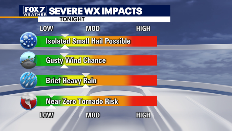
Storms will reportedly be expected mainly between 9 PM and 1 AM tonight as the line will be quickly moving. The main hazards with these storms would be localized damaging winds and hail.
Residents in Central Texas should stay weather aware this week and keep checking the latest forecast.

Evening weather forecast for March 14, 2022
After near-freezing temperatures last week, temps are finally starting to heat up. Scott Fisher has the latest details.
WHERE: The SPC is forecasting a SLIGHT RISK for severe weather in northeast Texas. That slight risk area extends to include the eastern 1/3rd of Bastrop County, all of Fayette and Lee counties. There is a VERY LOW RISK for severe weather in Central Texas including the remainder of Bastrop County, the eastern 1/3rd of Williamson County, and the eastern 1/5th of Travis County.
WHEN: This evening and overnight. Storms should form along I-35 between 8-10 pm, potentially becoming severe in our southeastern counties around 10:30 pm. The storms will depart our viewing area by midnight.
HOW BAD: Some storms will be strong enough to produce hail and gusty winds. The greatest threat for those severe weather conditions will be well southeast of I-35 into Lee, Bastrop, and Fayette counties, where the SLIGHT RISK is lightning will be expected in any thunderstorms that do form. There is nearly zero risk for tornadoes from this system.
ADDITIONAL NOTES: A stout cap is expected to be in place which will limit thunderstorm development though that also means that those that do form and get going will be strong. The strongest storms are expected to stay in the SLIGHT RISK area and mostly leave Austin and I-35 alone. Strong shearing at mid and upper levels will ensure updrafts maintain their intensity for a long time and a warm, humid air mass should power the storms through the night. The latest models (as of 10 am) indicate discrete thunderstorms forming near I-35 which means as they intensify they'll rapidly move away from the Austin metro.

Track your local forecast for the Austin area quickly with the free FOX 7 WAPP. The design gives you radar, hourly, and 7-day weather information just by scrolling. Our weather alerts will warn you early and help you stay safe during storms.
___
DOWNLOAD: FOX 7 AUSTIN NEWS APP
SUBSCRIBE: Daily Newsletter | YouTube
FOLLOW: Facebook | Instagram | Twitter