

Hurricane Ian vs Hurricane Charley: Exact same landfall location and strength but different impacts

During the last two decades, Lee County, Florida, has been ground zero for two major hurricanes with nearly identical strength, but that is where the similarities end between the two destructive storms.
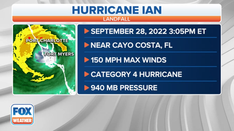
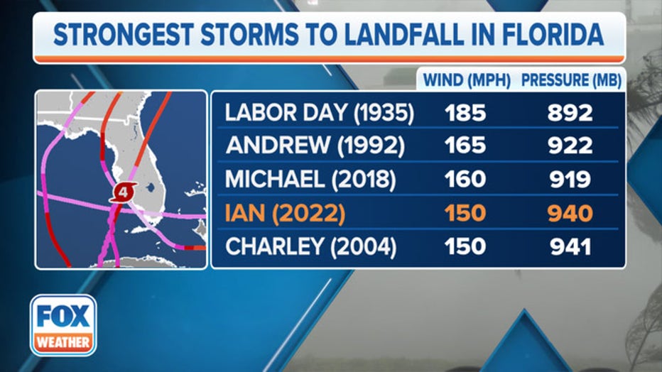
Back in August of 2004, Hurricane Charley made landfall on Cayo Costa Island as a Category 4 with 150 mph winds and a central pressure of 941 mb, and on Wednesday, Hurricane Ian matched Charley's strength.
Charley crisscrossed the Sunshine State, and by the time it exited off the east coast, a damage value of $22.9 billion (adjusted to 2022-dollar value) was done.
Damage assessments from Hurricane Ian will likely take several months to complete, but in terms of rain and surge, how many Floridians experienced damaging winds, the storm has already surpassed impacts from Charley.
Here are the top differences between the storms.
1. Size
The size of a hurricane can significantly affect the population impacted by damaging winds.
Hurricane Charley was on the small side of the hurricane scale and only produced sustained hurricane-force winds outwards of about 15 to 20 miles from the center.
This small composition limited the impacts to those who found themselves near the storm’s center, but the center rode along the busy I-4 corridor, home to millions of Floridians.
In comparison, Ian’s hurricane-force winds extended outwards around 50 miles, and tropical storm-force winds were experienced outward up to 175 miles from the center.
The wide core forced authorities to issue a Hurricane Warning for 15 million residents in Florida, including Orlando, Tampa, and the entire Southwest Coast.
HURRICANE IAN TIES 4TH-STRONGEST STORM TO MAKE LANDFALL IN FLORIDA
2. Scope of storm surge
Several factors can impact the size of a hurricane’s storm surge, but in the case of the two Gulf Coast landfalling cyclones, Ian vastly outdid Charley’s impacts.
The FOX Forecast Center said because of Ian’s width and how long the hurricane maintained a significant intensity played a role in how large the storm surge reached.
During Hurricane Charley, areas around Ft. Myers Beach and Captiva Island reported a water level rise of around 9 feet, but the surge was limited in scope.
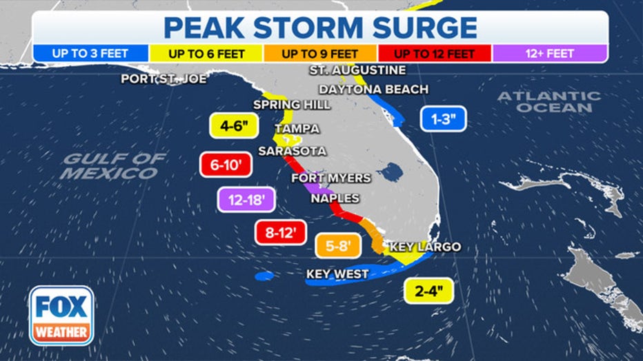
In comparison, Hurricane Ian produced a storm surge that Governor Ron DeSantis said reached at least 12 feet in some areas.
A significant storm surge was reported from the Florida Keys and stretched hundreds of miles along Florida’s Gulf Coast.
HURRICANE IAN STORM SURGE FLOODS HOMES, SENDS BOATS FLOATING DOWN STREETS OF SOUTHWEST FLORIDA
3. Forward speed
Due to different atmospheric features in play, Hurricane Ian crawled through the Florida Peninsula while Charley resembled the speed of a bullet train.
Ian was expected to take around 24 hours to cross the approximately 120-mile wide Peninsula, while Charley only took around 7 hours due to the storm’s forward speed.
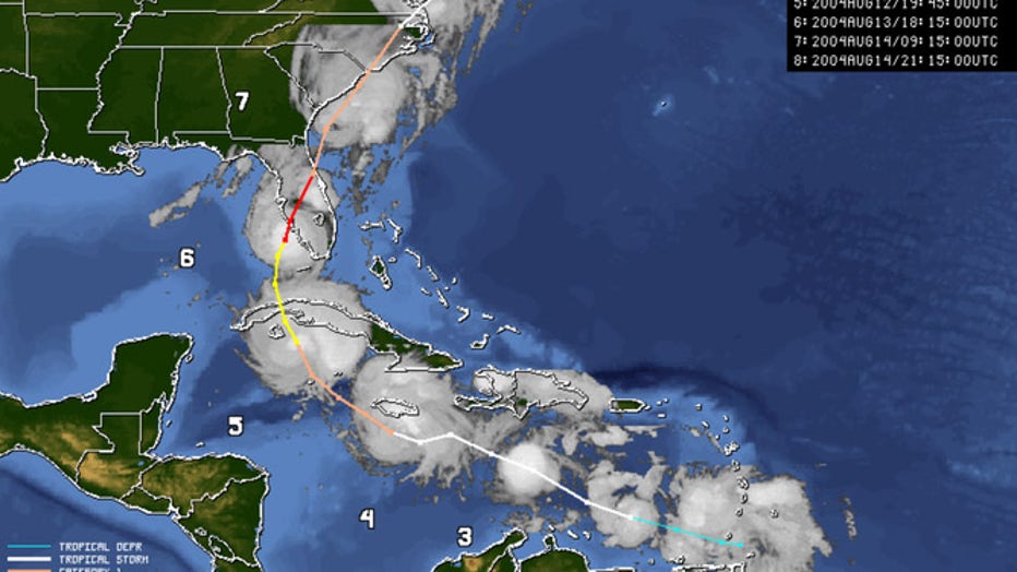
Hurricane Charley size and track (FOX Weather)
The fast movement allowed Charley to remain intact longer, which proved to be disastrous along the I-4 corridor as sustained hurricane-force winds were reported across the Peninsula.
The forward speed of a hurricane can lead to significant deviations in rainfall.
7 FACTS TO KNOW ABOUT HURRICANES
4. Rainfall amounts
Charley’s fast movement through the state limited rainfall amounts, and many communities reported seeing less than half a foot of rain from the 2004 event.
The disaster was not remembered for its flooding, as most of the torrential rainfall lasted for only hours.
Charley’s heaviest rainfall amounts were reported along Florida’s Gulf Coast, around the area of landfall.
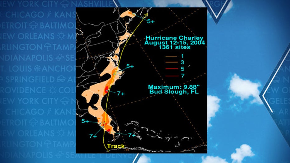
Hurricane Charley rainfall amounts (FOX Weather)
Due to Ian’s slow movement, communities that stretch from the Gulf Coast, along Interstate 4, to the Atlantic Ocean, could see double, triple or even quadruple the amount of rainfall that Charley produced.
The National Oceanic and Atmospheric Administration’s Weather Prediction Center warned some areas could see at least 20 inches of rain before the storm exits the coast.
LINK: Visit the FOX Weather Wire for live updates on Ian as it targets the Carolinas. Click here for the latest forecast, power outages and more.