

Strong thunderstorms possible, slight flash flooding risk in Central Texas

Noon weather forecast for September 4, 2020
Carlo Falco is tracking the storms and has your full forecast.
AUSTIN, Texas - The Weather Prediction Center is forecasting a slight risk for flash flooding in the Austin area and in Central Texas and that scatttered strong thunderstorms are possible.
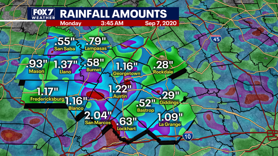
FOX 7 Austin meteorologist Carlo Falco says that nearly five inches of rain has already fallen across most of Central Texas with a few areas seeing upwards of seven (radar estimated) inches.
SIGN UP FOR FOX 7 AUSTIN EMAIL ALERTS
Flash flooding and river flooding are possible especially since thunderstorms are expected to continue off and on throughout the afternoon and into this evening.
An additional two to three inches of rain from thunderstorms are possible as the stationary front very slowly drags north and northeast with a weak upper level system that will enhance the intensity of the thunderstorms.
DOWNLOAD THE FOX 7 AUSTIN NEWS APP
This isn’t expected to produce any hail or even significant gusty winds but will help squeeze as much water out of the atmosphere as possible.
In addition, a tropical wave off the Gulf of Mexico is expected to enhance rainfall coverage and amounts tonight and especially tomorrow afternoon.
Track your local forecast for the Austin area quickly with the free FOX 7 WAPP. The design gives you radar, hourly, and 7-day weather information just by scrolling. Our weather alerts will warn you early and help you stay safe during storms. Download here.