

Baltimore bridge collapse debris seen in new sonar images

Temporary channel opens after bridge collapse
The Key Bridge Response Unified Command is working around the clock, clearing some of the debris from the channel after last week's collapse of the Francis Scott Key Bridge. Recently teams have cleared a temporary channel to get essential vessels through the debris. FOX 5 DC's Melanie Alnwick has the latest update.
BALTIMORE - Engineers are getting their first look at the "sheer magnitude" of the debris lurking underneath the Patapsco River in the wake of last week’s Francis Scott Key Bridge collapse.
New U.S. Navy imagery was released by the Army Corps of Engineers on Tuesday, a week after the span was destroyed by a barge collision. The images show the sonar view of the bottom of the river, where large pieces of the bridge are clearly recognizable.
The Corps of Engineers is leading the effort to clear the debris and reopen the main shipping channel so the busy Port of Baltimore can reopen. The first step in that process is assessing the bridge debris and coming up with a plan.
"These 3D images show the sheer magnitude of the very difficult and challenging salvage operation ahead," the Corps noted.
PREVIOUS: 200-ton piece of Key Bridge wreckage removed from river
Teams are using sonar to map the riverbed and debris field because of how cloudy the water is. Visibility is limited to just 1 to 2 feet because of the mud and loose bottom of the Patapsco River.
The water is so murky, in fact, that any divers in the water have to be guided by teams at the surface watching the sonar signals in real time, then relaying information down to the crews in the water.
"Divers are forced to work in virtual darkness, because when lit, their view is similar to driving through a heavy snowfall at night with high-beam headlights on," the Corps of Engineers press release explained. "No usable underwater video exists of the wreckage, because as one Navy diver stated, ‘there’s no need take video of something you can’t even see.’"
PREVIOUS: Baltimore bridge collapse revealed in up-close Coast Guard photos
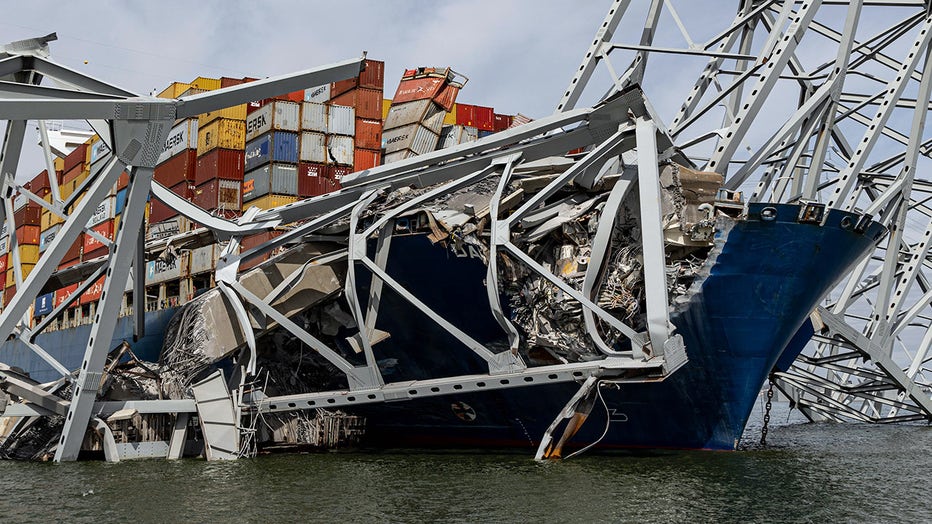
Wreckage from Key Bridge collapse (Photo by David Adams, U.S. Army Corps of Engineers, Baltimore District)
Crews on Monday were able to map out a temporary channel that will allow more ships to arrive on the scene and help with the salvage and clearing operation, while work has begun to start cutting through the bridge segments that remain above the waterline.
Despite the progress, Maryland Gov. Wes Moore cautioned Monday that cleanup of the site would be a slow and painstaking process.
"This is a steel bridge on top of a container ship in the middle of the Patapsco River. We’re talking about tons of steel that is mangled and cantilevered," Moore said. "We're talking about water that is so murky and filled with debris, divers can't see more than one foot in front of them. We're talking about a situation where the portion of the bridge beneath the water has been described by Unified Command as ‘chaotic wreckage’."