

What are the largest earthquakes to strike the US?

Recovery efforts after earthquake kills 11,000 in Turkey & Syria
Recovery efforts continue Wednesday as people remain trapped underneath rubble following Monday's earthquake that struck Turkey and Syria, killing at least 11,000 people. FOX's Greg Palkot joined LiveNOW from FOX's Josh Breslow from Turkey.
More than 11,00 have died in Turkey and Syria following a magnitude 7.8 earthquake Sunday and dozens of powerful aftershocks. It was the worst earthquake to hit that region in over 100 years.
There have only been a handful of notable earthquakes of that size to strike the U.S. The earliest dates back to 1700.
1. Anchorage, Alaska (magnitude 9.2) - March 1964
The most powerful recorded earthquake in U.S. history happened on March 27, 1964, at 5:36 p.m. local time, the U.S. Geological Survey reports. The magnitude 9.2 earthquake occurred in the Prince William Sound region of Alaska.
It is also the second-largest earthquake ever recorded, next to the magnitude 9.5 earthquake in Chile in 1960.
The earthquake lasted approximately 4.5 minutes, with its epicenter about 75 miles east of Anchorage.
The earthquake and ensuing tsunami took 125 lives (tsunami 110, earthquake 15), and caused about $311 million in property loss, according to NOAA's National Centers for Environmental Information.
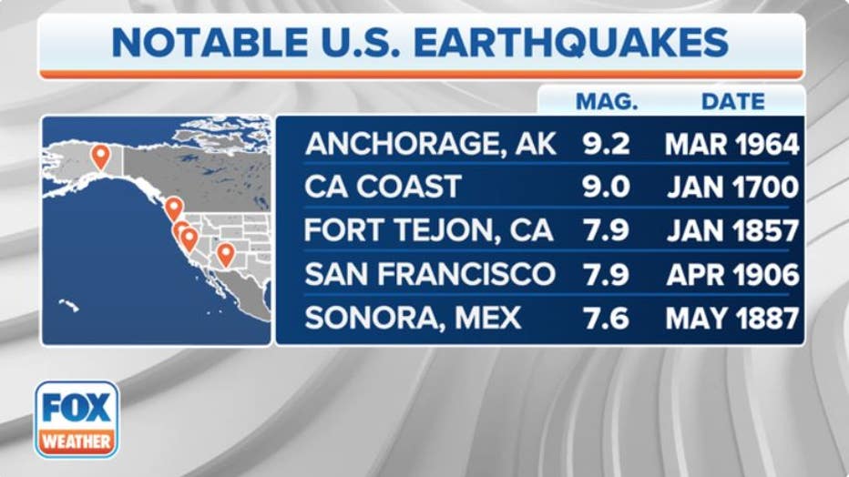
Here's a look at the top 5 notable U.S. earthquakes. (FOX Weather)
2. Pacific Coast (magnitude 9.0) - January 1700
On Jan. 26, 1700, a massive 9.0 quake ruptured hundreds of miles along the deep offshore waters of the Pacific Coast, forever altering the local landscape and sending a tsunami not only across much of North America's western shores but also thousands of miles across the Pacific Ocean into Japan.
The undersea Cascadia thrust fault ruptured along a 620-mile length from mid-Vancouver Island to northern California, producing tremendous shaking and a huge tsunami that swept across the Pacific.
The earthquake shaking collapsed houses of the Cowichan people on Canada's Vancouver Island and caused numerous landslides. The shaking was so violent that people could not stand and so prolonged that it made them sick, the Canadian government writes.
9.0 QUAKE ROCKED THE PACIFIC COAST 323 YEARS AGO AND SENT AN ‘ORPHAN TSUNAMI’ TO JAPAN
Scientists determined entire forests died across hundreds of miles when the coasts of what are today Washington, Oregon and northern California suddenly dropped 4-6 feet, flooding the coastline with seawater amid an incredible tsunami. On the west coast of Vancouver Island, the tsunami completely destroyed the winter village of the Pachena Bay people with no survivors.
The tsunami swept across the Pacific also causing destruction along the Pacific coast of Japan.
3. Fort Tejon, California (magnitude 7.9) – January 1857
The USGS said relatively little is known about the seismic activity near Parkfield, California at the time of the great Fort Tejon earthquake on Jan. 9, 1857.
A right-lateral slip on the San Andreas Fault produced shaking that lasted 1 to 3 minutes and that was felt over more than 135,000 square miles of central and southern California. The state currently occupies 163,695 square miles.
Property loss was heavy at Fort Tejon, an Army post about 4 miles from the San Andreas fault, the USGS said. About 12 miles west of Fort Tejon, trees were uprooted, and buildings were destroyed between Fort Tejon and Elizabeth Lake.
One person was killed in the collapse of an adobe house at Gorman, the USGS reports.
4. San Francisco (magnitude 7.9) – April 1906
The California earthquake of April 18, 1906, ranks as one of the most significant earthquakes of all time, the USGS reports.
At 5:12 a.m. local time, a foreshock occurred with sufficient force to be felt widely throughout the San Francisco Bay Area, according to the USGS. The great earthquake broke loose some 20 to 25 seconds later, with an epicenter near San Francisco. The violent aftershocks lasted some 45 to 60 seconds.
"The frequently quoted value of 700 deaths caused by the earthquake and fire is now believed to underestimate the total loss of life by a factor of 3 or 4," the USGS said. "Most of the fatalities occurred in San Francisco, and 189 were reported elsewhere."
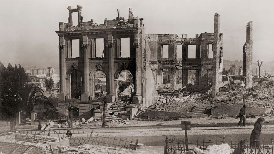
Ruins in San Francisco, California, United States of America, after the earthquake of April 18, 1906. (Photo by: Universal History Archive/Universal Images Group via Getty Images)
5. Sonora, Mexico (magnitude 7.6) – May 1887
On May 3, 1887, a major seismic event, with an estimated magnitude of 7.2, shook much of the southwest U.S. and Mexico, the Arizona Geological Survey reports.
The epicenter was south of the Arizona-Mexico border in the San Bernardino Valley. It spanned over an area of nearly 772,000 square miles.
It caused 51 deaths in northern Sonora, Mexico, and major destruction of property in southeast Arizona, as well as adjacent portions of Mexico. Moderate damage also occurred in New Mexico.
Historically, it is the largest earthquake known to have caused damage in Arizona, according to the Arizona Geological Survey.
Honorable mention
There have been a number of other strong quakes in American history that may not have ranked based on their magnitude, but are notable for the damage and destruction they caused.
New Madrid, Missouri (magnitude 7.5 estimated) – February 1812
On February 7, 1812, the strongest of a series of large earthquakes that struck near the town of New Madrid in southeastern Missouri.
At the time, New Madrid was the largest settlement on the Mississippi River between St. Louis, Missouri, and Natchez, Mississippi. But eventually, scientists discovered that New Madrid also sat on the most seismically active area east of the Rocky Mountains through 2014.
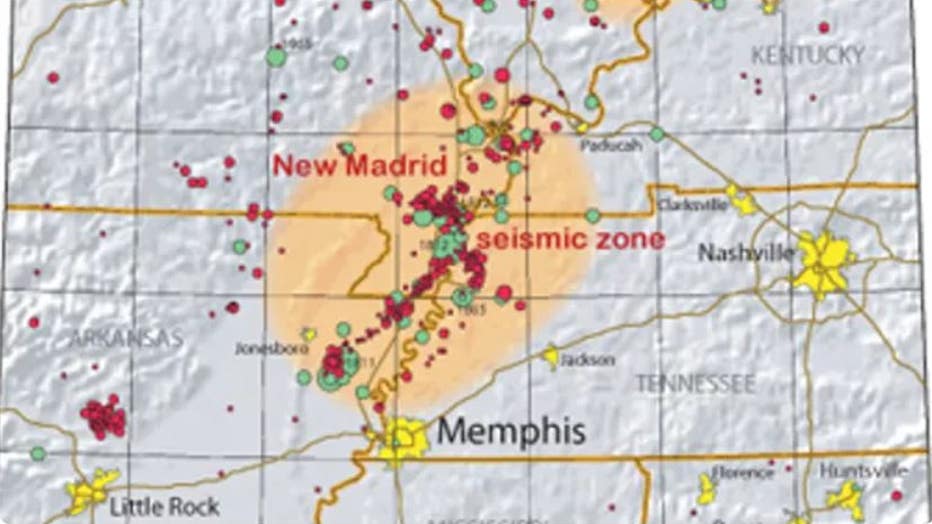
On February 7, 1812, the strongest of a series of large earthquakes struck near the town of New Madrid in southeastern Missouri. (U.S. Geological Survey)
This New Madrid seismic zone produced a series of earthquakes and hundreds of powerful aftershocks over the winter of 1811-1812, including three of the largest U.S. earthquakes ever recorded east of the Rocky Mountains.
The largest of the three struck on Feb. 7, 1812, at 3:45 a.m. local time. Measuring at a magnitude of about 7.5, the earthquake eviscerated New Madrid. The earthquake was also powerful enough to severely damage homes in St. Louis, located about 160 miles away.
WHEN AN EARTHQUAKE CAUSED THE MISSISSIPPI RIVER TO FLOW BACKWARDS
The quake even modified the Mississippi River bank, making the river flow briefly flow backwards in the wake of the temblor.
Loma Prieta Quake-San Francisco Bay Area (magnitude 6.9) – October 1989
The 6.9 quake that hit on Oct. 17, 1989 made itself instantly known to America as it struck during the broadcast of Game 3 of the World Series that was minutes from beginning in San Francisco’s Candlestick Park.
Soft soils in the region amplified the shaking by a factor of two, and caused severe damage across the Bay Area. The quake killed 63 people and caused $6-10 billion in property loss, according to the USGS. Forty-two of the victims were from the collapse of the double-decked Interstate 880/Cypress Freeway in Oakland.
The remains of the Cypress Freeway, which ran through the center of Oakland, following the San Francisco, or Loma Prieta, Earthquake of 1989. (Photo by Jim Sugar/Corbis via Getty Images)
The freeway’s collapse led to changes along the West Coast, with San Francisco and Seattle later demolishing similarly-constructed double-decker freeways amid fears they were vulnerable to a future collapse in a quake. The annual Great American Shakeout where the nation is tasked with practicing earthquake drills is typically held on or around this quake's anniversary.
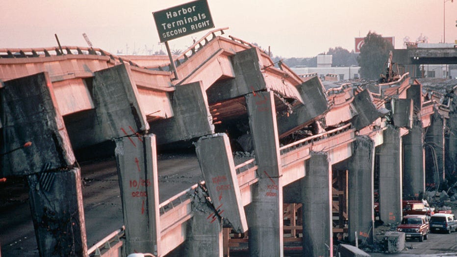
Northridge Quake-Los Angeles area (magnitude 6.7) – January 1994
Nearly 5 years after the Bay Area was rocked, it was southern California’s turn as a 6.7 quake jolted the Los Angeles area residents from bed in the pre-dawn hours of Jan. 17, 1994.
The quake killed at least 57 people and caused up to $20 billion in damage costs, making it the costliest earthquake disaster in U.S. History.
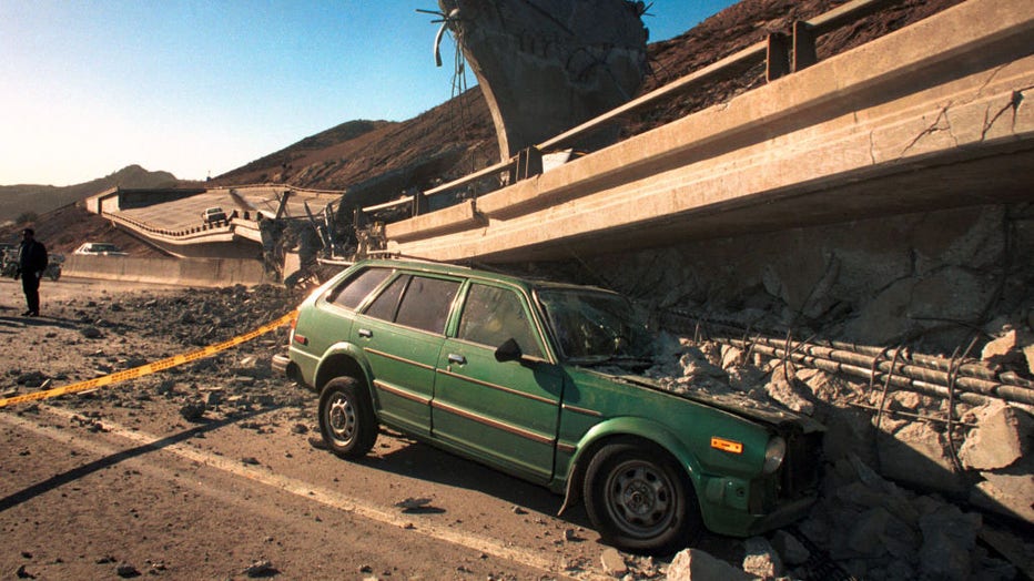
Northridge 6.7 earthquake caused major damage throughout Los Angeles including the freeway collapse of Interstate 5 and Highway 14 overpasses, Jan. 17, 1994, in Los Angeles, California. (Photo by Bob Riha, Jr./Getty Images)
The earthquake severely tested building codes, earthquake-resistant construction, and emergency preparedness and response procedures, according to the USGS.
The quake brought several surprises to seismologists, including strong vertical thrust shown during the quake, creating unexpected structural failures in the vicinity of the fault. Steel frames failed in more than 100 buildings that were designed for such quakes. And more than 170 freeway bridges failed despite a decades-long program to retrofit freeways.