

Austin weather: Second line of storms moving through
AUSTIN, Texas - Another severe weather alert day is ahead of us.
9:20 p.m. update
Severe Thunderstorm Warnings are in effect until 9:30 p.m. for
- Northwestern Hays County
- West central Travis County
- Northeastern Blanco County
- Southeastern Llano County
- Southwestern Burnet County
The NWS is warning about tennis ball sized hail and 60 mph wind gusts.
8:30 p.m. update
The storm is causing road closures across Austin:
- Shoal Creek at Lamar
- Mopac at Steck
- Old Spicewood Springs low water crossings #11, #12, and #13
- W 9th Street and N Lamar Blvd
7:30 p.m. update
Another Severe Thunderstorm Warning is in place for parts of Llano and Burnet counties as a second line of storms is coming through Central Texas.
The NWS says just before 7:30 p.m. a severe thunderstorm was located by radar near Cherokee, or about 12 miles south of San Saba, moving southeast at 30 mph.
The NWS is warning about tennis-ball-size hail and 60 mph wind gusts.
Locations impacted include: Burnet, Kingsland, Llano, Buchanan Dam, Gainesville, Buchanan Lake, Village, Inks Lake State Park, Lone Grove, Bluffton, Baby Head, Stolz, Longhorn Cavern State Park, and Tow.
7:15 p.m. update
65,009 Austin Energy customers are without power right now due to 174 active outages, according to Austin Energy's outage map.
The largest numbers of outages are reported in Central Austin near UT Austin, just west of Mopac at Lake Austin Boulevard, and the Brentwood area.
Austin Energy shared this on their website:
Austin Energy crews are working to restore power from the severe weather. All available crews are in service. Severe storms brought high winds, hail and lightning that damaged electrical equipment and broke tree limbs.
Austin Energy is activating its emergency procedures so it can assess the system and respond to the outages. There is currently no estimated time of restoration for outages related to the storm.
Thank you for your patience. We are working 24/7 to restore power to customers who can safely receive power.
6:45 p.m. update
The Severe Thunderstorm Warning is now covering north central Caldwell County, southeastern Travis County and central Bastrop County until 7:30 p.m.
The NWS says that just after 6:30 p.m., a severe thunderstorm was indicated by radar near Austin, moving southeast at 35 mph.
The NWS is warning about baseball-size hail and 60 mph wind gusts.
Locations include: Austin, Pflugerville, Elgin, Bastrop, Austin Bergstrom Int Airport, Windemere, Manor, West Lake Hills, Rollingwood, Mustang Ridge, Paige, Camp Swift, Circle D-KC Estates, Cedar Creek, Wyldwood, Hornsby Bend, Webberville, Phelan, Bastrop State Park, and Hills Prairie.
6 p.m. update
Travis and Williamson counties are still under a Severe Thunderstorm Warning until 7 p.m.
The NWS says that just before 6 p.m., a severe thunderstorm was located near Liberty Hill and about nine miles northwest of Cedar Park and moving southeast at 25 mph.
The NWS is warning about hail three inches in diameter and 60 mph wind gusts. The NWS says that people and animals outdoors will be severely injured and residents could see shattered windows and extensive damage to roofs, siding and vehicles.
Locations impacted include: Austin, Round Rock, Cedar Park, Georgetown, Pflugerville, Taylor, Anderson Mill, Windemere, Serenada, Leander, Hutto, Lakeway, Lago Vista, Bee Cave, West Lake Hills, Hudson Bend, Liberty Hill,
Rollingwood, Barton Creek, and Georgetown Dam.
5 p.m. update
Travis and Williamson counties are now under a Severe Thunderstorm Warning along with Burnet County.
The warning is in effect until 6 p.m.
Just after 5 p.m., a severe thunderstorm was located near Lake Victor, about eight miles northeast of Burnet, moving southeast at 30 mph.
The NWS is warning about golf-ball-sized hail and 60 mph wind gusts.
Locations impacted include: Cedar Park, Georgetown, Burnet, Bertram, Leander, Lakeway, Lago Vista, Liberty Hill, Jarrell, Florence, Watson, Oatmeal, Briggs, Sun City, Lake Victor, Mahomet, Sunnylane, Joppa, Andice, and Shady
Grove.
4:30 p.m. update
A Severe Thunderstorm Warning has been issued for Burnet County through 5:15 p.m.
At 4:16 p.m., a severe thunderstorm was located over Bend, or 15 miles southeast of San Saba, moving southeast at 30 mph, according to the National Weather Service.
The NWS is currently warning about baseball-sized hail and 70 mph wind gusts. The agency says this is a "destructive" storm for rural northwestern Burnet County.
Locations impacted by this warning include Burnet, Lake Victor, Sunnylane and Colorado Bend State Park.
Much of Central Texas is also under a Severe Thunderstorm Watch until 10 p.m. tonight (May 28).
The backstory:
The storm threat is ramping up later today.
The heating of the day will interact with the stalled front and an upper low out to our west.
The Storm Prediction Center has upgraded the area to a LEVEL 2 severe weather day.
Timeline:
The new storm development late in the day will start in the Hill Country.
A complex of storms will advance east across the entire area this evening.
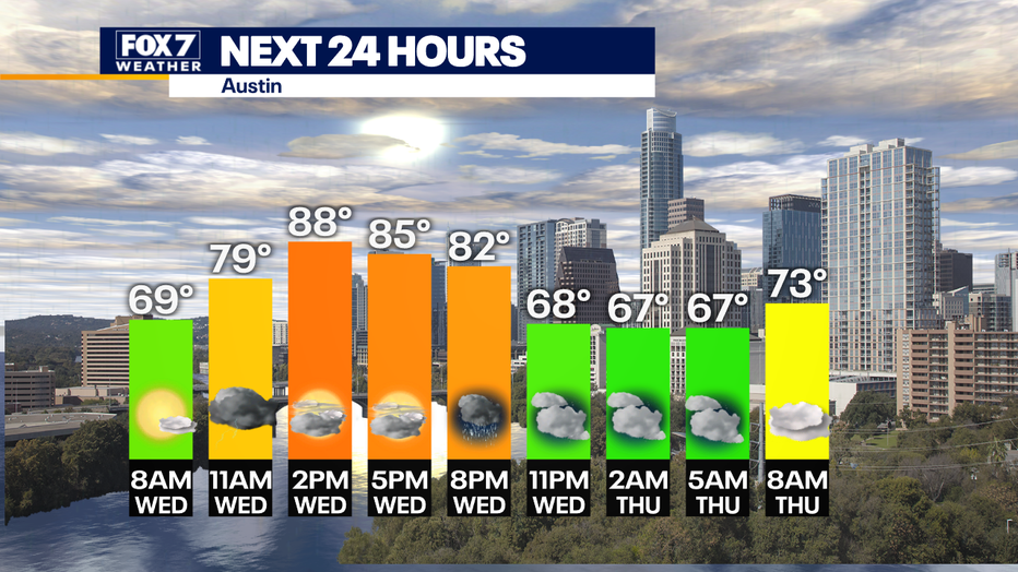
Storms should be in the Hill Country from 5 p.m. to 7 p.m.
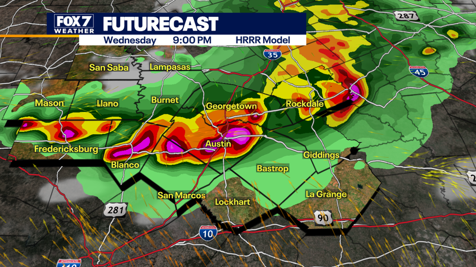
Then from 7 p.m. to 9 p.m. they will be in the Austin metro area.
Eastern counties should expect storms from 9 p.m to 11 p.m.
Why you should care:
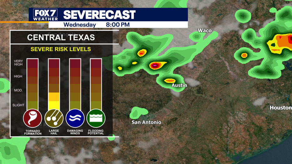
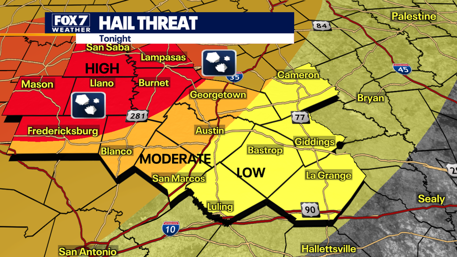
Large hail, quarter to baseball-sized, is possible mainly in the Hill Country with a slight chance of an isolated tornado and then damaging winds and heavy rain for the rest of the area.
The second round this evening will be more intense than the one around midday.
Straight-line winds of 58 mph or more are possible.
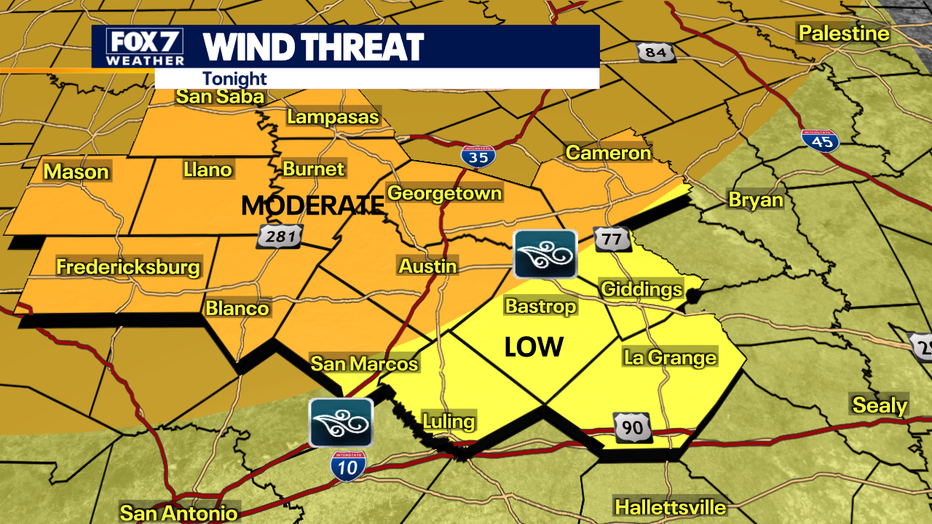
The tornado threat is low, but it can't be ruled out.
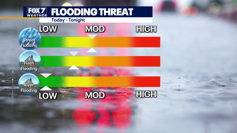
Flooding will mostly be localized with street flooding the main concern.
What you can do:
Stay weather aware and track your local forecast for the Austin area quickly with the free FOX 7 WAPP.
The design gives you radar, hourly, and 7-day weather information just by scrolling. Our weather alerts will warn you early and help you stay safe during storms.
The Source: Information from meteorologist Zack Shields.