

Hurricane Laura continues strengthening in Gulf of Mexico; forecast to become major hurricane

Tropical Weather Update
The 10pm forecast has shifted Laura back to the east a little with most of the Houston area being taken out of the cone. If this holds, it would mean less of an impact on SE Texas, but it is still too early to know.
HOUSTON - Hurricane Laura formed is expected to strengthen into a major hurricane by Wednesday night, according to the National Hurricane Center.
Late Tuesday evening, NOAA hurricane hunter aircraft data indicated that Laura had maximum sustained winds of 90 mph, with higher gusts.
On the forecast track, the center of Laura will move across the northwestern Gulf of Mexico tonight.
LIST: Evacuations ordered in these SE Texas counties and cities
According to the NHC, Hurricane Laura should approach the upper Texas and southwest Louisiana coasts on Wednesday night and move inland near those areas late Wednesday night or Thursday morning.
Laura could become a Category 3 hurricane before making landfall.
MORE TROPICAL WEATHER FORECASTS FROM FOX 26
Marco, which was once a hurricane, weakened to a tropical depression on Monday and further weakened to a remnant low as of Tuesday. It is forecast to dissipate by early Wednesday, if not sooner.
HURRICANE LAURA
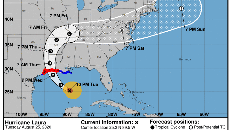
As of the 10 p.m. update from the National Hurricane Center, Hurricane Laura is located about 405 miles southeast of Lake Charles, Louisiana and 430 miles from Galveston.
Laura is moving toward the west-northwest near 17 mph, and this general motion should continue overnight. A turn toward the northwest is forecast on Wednesday, and a northwestward to north-northwestward motion should continue through Wednesday night.
On the forecast track, the center of Laura will move across the northwestern Gulf of Mexico on Wednesday. The hurricane should approach the upper Texas and southwest Louisiana coasts on Wednesday evening and move inland near those areas Wednesday night or Thursday morning.
Maximum sustained winds have increased to near 90 mph with higher gusts. Significant strengthening is forecast during the next 24 hours, and Laura is expected to be a major hurricane at landfall. Rapid weakening is expected after Laura makes landfall.
Hurricane-force winds extend outward up to 45 miles from the center and tropical-storm-force winds extend outward up to 175 miles. An NOAA buoy in the central Gulf of Mexico recently reported a sustained wind of 45 mph and a gust to 54 mph.
A Storm Surge Warning is in effect for:
- San Luis Pass Texas to the Mouth of the Mississippi River
A Hurricane Warning is in effect for:
- San Luis Pass Texas to Intracoastal City Louisiana
A Tropical Storm Warning is in effect for:
- Sargent Texas to San Luis Pass
- East of Intracoastal City Louisiana to the Mouth of the Mississippi River
A Storm Surge Watch is in effect for:
- Freeport Texas to San Luis Pass
- Mouth of the Mississippi River to Ocean Springs Mississippi
- Lake Pontchartrain, Lake Maurepas, and Lake Borgne
A Hurricane Watch is in effect for:
- East of Intracoastal City to west of Morgan City Louisiana
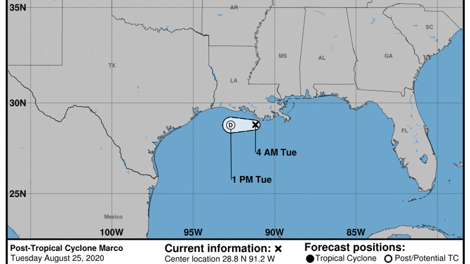
POST-TROPICAL CYCLONE MARCO
As of the 4 a.m. Tuesday update, Marco has become a remnant low located about 60 miles south of Morgan City, Louisiana.
The post-tropical cyclone was moving toward the west near 10 mph, and this general motion is expected to continue for the next day or so. On the forecast track, Marco should continue moving westward just offshore the coast of Louisiana until the system dissipates.
Post-Tropical Cyclone Marco is forecast to dissipate by early Wednesday, if not sooner.
STAY ALERT: Texans urged to monitor weather as tropical systems approach the Gulf Coast
Some counties and cities in southeast Texas have ordered voluntary and mandatory evacuations ahead of the storm. The City of Galveston issued a mandatory evacuation order on Tuesday. Jefferson County also ordered a mandatory evacuation. Meanwhile, Harris County Judge Lina Hidalgo declared a voluntary evacuation for Zones A and B.
LIST: Evacuations ordered in these SE Texas counties and cities
MORE: Hurricane Evacuation Routes
On Monday, Mayor Sylvester Turner and Harris County Judge Lina Hidalgo urged the public to take several precautionary steps ahead of the the storm. People should stock their homes with non-perishable food items just in case there is a loss of power.
Turner and Hidalgo expressed that Tropical Storm Laura "isn't Harvey", but the storm could have a lasting effect for some if they don't take the proper precaution.
CLICK HERE FOR SCHOOL CLOSURES
CLICK HERE FOR BUSINESS CLOSURES
RELATED: Hurricanes and the pandemic: How should Houstonians prepare
Texas Governor Greg Abbott has issued a state disaster declaration ahead of the landfall of the two tropical systems moving into the Gulf of Mexico.
Abbott has also requested an Emergency Declaration from President Trump and FEMA for Public Assistance Category B (Emergency Protective Measures), Direct Federal Assistance, and Hazard Mitigation statewide.
The following counties are a part of the state disaster declaration: Aransas, Bexar, Brazoria, Calhoun, Cameron, Chambers, Galveston, Hardin, Harris, Jackson, Jasper, Jefferson, Kenedy, Kleberg, Liberty, Matagorda, Newton, Nueces, Orange, Refugio, San Patricio, Victoria, and Willacy.
MORE: Hurricane Preparedness Shopping List

‘Calm Before the Storm’: Louisiana resident prepares for wild weather
A resident in Grand Isle, Louisiana, showed his “hurricane preparations” on August 23, with Tropical Storm Marco predicted to make landfall in the state on August 24, according to the National Hurricane Center (NHC). Credit: Beav Fabacher via Storyful
If both Marco and Laura were both upgraded to hurricanes at the same time, it would have been the first time two hurricanes were in the Gulf at the same time since the start of record-keeping in 1851.
RELATED: Tropical Depression 14 could make landfall on southeast Texas coast near Harvey anniversary
Forecasters predicted a historically active season this year, and so far, that has proven accurate. Of the 12 named storms so far this season, nine were the earliest use of that letter-name ever, the latest being 'Laura.'
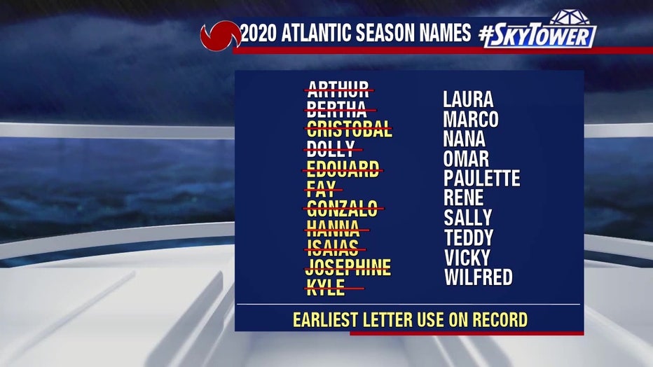
Should all of the alphabetical names get used up, the National Hurricane Center will begin using the Greek alphabet to name storms. That's only happened once before, during the record-breaking season of 2005 -- remembered most for hurricanes Katrina, Rita, and Wilma.

Streets flooded in Jamaica as Tropical Storm Laura passes through Caribbean
Streets were flooded in Kingston, Jamaica, as Tropical Storm Laura made its way through the Caribbean on August 23, according to local media reports. The Office of Disaster Preparedness and Emergency Management (ODPEM) reported flooding in the Mandela Terrace, Marverley and Chelsea Avenue areas of Kingston. Credit: @Imi_Dee via Storyful
The FOX 26 Weather Team is closely monitoring developments. They will continue to keep you up-to-date online, on-air, and on social media.
You can also stay up-to-date 24 hours a day by downloading the free FOX 26 weather app. You'll receive weather alerts for your location, along with video weather updates.