

Severe weather possible as warnings issued for parts of Central Texas

Rainy, stormy start to Friday with some severe weather possible
Storms are rolling through parts of Central Texas. Zack Shields has the details in his full forecast.
AUSTIN, Texas - Big changes from yesterday as the day starts with some rain.
It's a rainy and stormy finish to the week with a cold front coming to town.
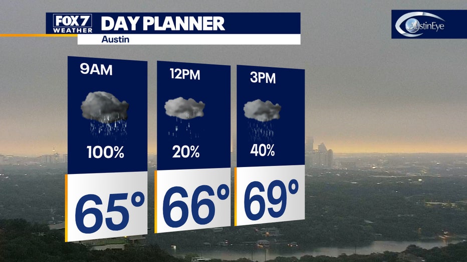
A line of storms is likely this morning then we will get a break by noon. Then a few lingering showers are possible by late afternoon as they rotate around the exiting low-pressure system.
The severe weather threat will be low but all of us getting some good soaking rain.
The combination of clouds and cool northerly wind will keep temperatures in the 60s today.
A few severe thunderstorm warnings had been issued earlier in the day.
Gillespie, Llano, and Burnet were under a severe thunderstorm warning until 6:30 a.m. and Travis, Burnet, and Williamson were under one until 7:15 a.m.
The storms are moving quickly through and the Austin area should expect downpours, gusty winds, and lightning. Some small hail is also possible.
Track your local forecast for the Austin area quickly with the free FOX 7 WAPP. The design gives you radar, hourly, and 7-day weather information just by scrolling. Our weather alerts will warn you early and help you stay safe during storms.