

Tornado watch issued for several Central Texas counties

10 PM weather forecast for March 21, 2022
Tornadoes swept across Central Texas, Carlo Falco has the latest details
TRAVIS COUNTY, Texas - The National Weather Service issued a tornado watch for most Central Texas counties on Monday, March 21. The National Weather Service had issued the tornado watch until 1 a.m.
The following counties in Central Texas were under a tornado watch: Gillespie County, Hays County, Bastrop County, Caldwell County, Lee County, Blanco County, Travis County, Llano County, Burnet County, Williamson County, Fayette County, Bell County, Milam County and Lampasas County.
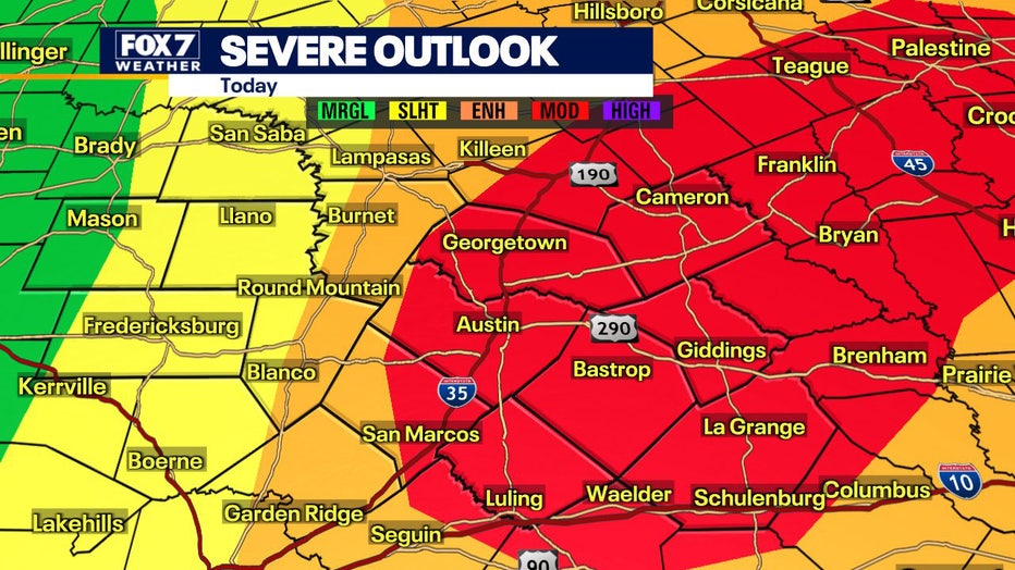
Much of the area has been upgraded from enhanced for moderate risk for severe weather for the Central Texas area for Monday, March 21. The upgrade in risk is specifically due to the tornado and hail potential. Strong tornadoes are possible this evening with golf ball to baseball size hail possible late this afternoon and evening.
FOX 7 Austin meteorologist Carlo Falco says storm threat modes will begin as hail, transition to large or very large hail, before becoming a tornado threat. Storms should fire along a dry line in the TX Hill Country near Hwy-281, moving east with tornado & hail threat approaching I-35 by 4-7 p.m.
The storms will move east, maintaining or increasing in intensity across our eastern counties and along the coastal plain. They're expected to depart the Austin area by 9-11 p.m.
Stay weather aware and follow along in FOX 7's Weather Center to view the latest forecast and interactive radar.
Track your local forecast for the Austin area quickly with the free FOX 7 WAPP. The design gives you radar, hourly, and 7-day weather information just by scrolling. Our weather alerts will warn you early and help you stay safe during storms.
___
MORE HEADLINES:
Multiple tornadoes cause damage across Central Texas
Moderate risk for severe weather for Central Texas area, hail likely
Central Texas school districts dismissing early due to severe weather
___
DOWNLOAD: FOX 7 AUSTIN NEWS APP
SUBSCRIBE: Daily Newsletter | YouTube
FOLLOW: Facebook | Instagram | Twitter