Most of Central Texas under slight risk of severe storms
Large hail is the main threat with the storms followed by lightning and strong winds.
AUSTIN, Texas - A severe thunderstorm watch remains in effect for parts of the Hill Country until 3 pm. A SEVERE THUNDERSTORM WATCH means that conditions are ripe for severe thunderstorms to form.
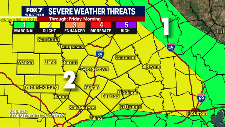
The Storm Prediction Center has included the Austin Metro and most of the Hill Country under a SLIGHT RISK of severe storms.
Large hail is the main threat with the storms followed by lightning and strong winds. Severe thunderstorms could create quarter to golf ball size with the strongest storms producing up to baseball size hail.
The threat of damaging winds is low and the tornado threat is nearly zero.
DOWNLOAD THE FOX 7 AUSTIN NEWS APP

Noon weather forecast for April 15, 2021
A severe thunderstorm watch has been issued for the Hill Country until 3 pm! Stay weather aware with the FOX 7 WAPP!
As of 2 pm, the SEVERE THUNDERSTORM WATCH has been canceled for Gillespie County. Blanco, San Saba, Burnet, and Mason Counties are still under the Severe Thunderstorm Watch until 3 p.m.
The storms will approach the I-35 corridor in the next couple of hours. Hail, lightning, and briefly torrential rain will continue to be the main threats as these storms cross the interstate.
SIGN UP FOR FOX 7 AUSTIN EMAIL ALERTS
Track your local forecast for the Austin area quickly with the free FOX 7 WAPP. The design gives you radar, hourly, and 7-day weather information just by scrolling. Our weather alerts will warn you early and help you stay safe during storms.